Latest GeoComm updates

GeoComm Launches Map Converter to Accelerate the Conversion of Static Floorplans into Response Ready Indoor GIS Data
New public safety grade solution accelerates static floorplan-to-GIS conversion, helping public safety, school safety, healthcare, and critical infrastructure organizations improve situational awareness, coordination, and response readiness ST. CLOUD, Minn. – June 24, 2026 – GeoComm, leading provider of public safety grade location data and mapping solutions, today announced GeoComm Map Converter, a new solution designed to help organizations...

Drone as First Responder Programs Need Indoor Maps Too
By John Brosowsky, SVP of Innovation, and Tracy “Mac” McElvaney, Chief Product & Innovation Officer, GeoComm Bridging the Gap Between Aerial and Interior Response Drone as First Responder programs are increasingly becoming part of modern public safety operations. They can provide rapid aerial situational awareness, help agencies assess scenes sooner, and give commanders and field responders more context before personnel...

GeoComm Joins Make Our Schools Safe as 2026 Annual Partner to Help Strengthen School Emergency Response
News provided by GeoComm, Inc Jun 03, 2026, 10:31 ET Partnership connects school safety advocacy with public-safety-grade indoor mapping to help schools and first responders access critical information when every second matters. ST. CLOUD, Minn. and PARKLAND, Fla., June 3, 2026 /PRNewswire/ — GeoComm, a trusted provider of Public Safety Grade indoor mapping and location intelligence solutions,...
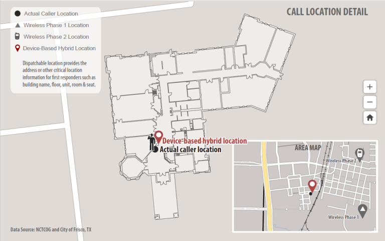
Vertical and Indoor 9-1-1 Location Mapping
Today more and more people rely on mobile phones as their primary phone service and are disconnecting wireline service altogether. As a result, more 9-1-1 calls are being placed from mobile phones than ever before, including from inside buildings where E9-1-1 mobile phone location technology does not work very well. Thanks to new FCC rules on this topic, wireless carriers and major industry technology players are now working to quickly address this issue.

RapidSOS and GeoComm Partner to Provide Accurate Location and Enhanced Data to 9-1-1 Centers using GeoComm Mapping Systems
GeoComm and RapidSOS are pleased to announce a strategic partnership to provide public safety agencies that use GeoComm 9-1-1 Public Safety Answering Point (PSAP) mapping systems with accurate location and additional data from the RapidSOS Clearinghouse. Through this partnership, PSAP’s working with GeoComm will be able to harness data from the RapidSOS NG911 Clearinghouse — including accurate handset location from all smartphone location sensors natively embedded into the 9-1-1 call flow.