Latest GeoComm updates

GeoComm Launches Map Converter to Accelerate the Conversion of Static Floorplans into Response Ready Indoor GIS Data
New public safety grade solution accelerates static floorplan-to-GIS conversion, helping public safety, school safety, healthcare, and critical infrastructure organizations improve situational awareness, coordination, and response readiness ST. CLOUD, Minn. – June 24, 2026 – GeoComm, leading provider of public safety grade location data and mapping solutions, today announced GeoComm Map Converter, a new solution designed to help organizations...

Drone as First Responder Programs Need Indoor Maps Too
By John Brosowsky, SVP of Innovation, and Tracy “Mac” McElvaney, Chief Product & Innovation Officer, GeoComm Bridging the Gap Between Aerial and Interior Response Drone as First Responder programs are increasingly becoming part of modern public safety operations. They can provide rapid aerial situational awareness, help agencies assess scenes sooner, and give commanders and field responders more context before personnel...

GeoComm Joins Make Our Schools Safe as 2026 Annual Partner to Help Strengthen School Emergency Response
News provided by GeoComm, Inc Jun 03, 2026, 10:31 ET Partnership connects school safety advocacy with public-safety-grade indoor mapping to help schools and first responders access critical information when every second matters. ST. CLOUD, Minn. and PARKLAND, Fla., June 3, 2026 /PRNewswire/ — GeoComm, a trusted provider of Public Safety Grade indoor mapping and location intelligence solutions,...

GeoComm Welcomes New President and Chief Operating Officer
GeoComm is pleased to announce the addition of Jeff Liebl as their newly appointed President and Chief Operating Officer (COO). Liebl joins John Bryant, GeoComm Chief Executive Officer in leading the company.
GeoComm Announces Early Release Program for New Vertical Location Service Aimed at Making 9-1-1 Caller Z-Axis Positioning Actionable
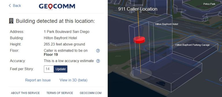
GeoComm is leading the way into the vertical frontier of Public Safety Location Intelligence® with the release of a new product, GeoComm Vertical Location Services. This offering provides the missing link to making the z-axis actionable during 9-1-1 calls by converting raw positioning measurements from 9-1-1 callers’ cell phones into dispatchable locations including building name, street address, height above the ground, and probable floor level, while also generating a 3D visualization of the caller’s location inside a building.
The Next Frontier of 9-1-1 Mapping – Indoors
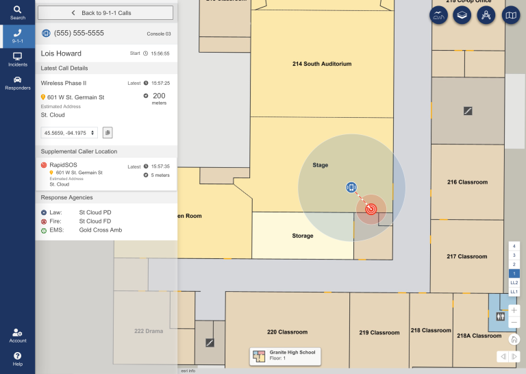
For many years the focus for Public Safety Grade GIS has been on site structure address points, road centerlines, service boundaries, and PSAP boundaries for routing 9-1-1 calls in a NG 9-1-1 systems. As we progress towards full NG9-1-1 implementations, having indoor context about the location of calls within indoor spaces will be critical for telecommunicators and first on scene responders.

GeoComm Celebrates Twenty-Five Year Esri Partner Network Partnership
GeoComm, provider of Public Safety Location Intelligence®, is excited to celebrate an important milestone - twenty-five years as a partner in the Esri Partner Network (EPN). Esri is the global leader in geographic information systems (GIS) and location intelligence. GeoComm’s long-term Esri partnership demonstrates a commitment to designing, developing, and leveraging Esri technology for optimized use in the public safety market.

GeoComm Partners with NextNav to Improve Emergency Response Indoors
GeoComm is pleased to announce a new partnership with NextNav, a leader in z-axis vertical positioning, to enhance floor-aware indoor mapping for E9-1-1. This partnership will dramatically improve geolocation of callers to provide floor-level altitude in multistory buildings in urban areas across the country.
Customer Profile: Rio Grande Council of Government (RGCOG)
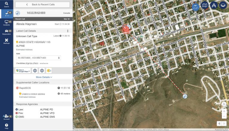
Rio Grande Council of Government (RGCOG) went live with GeoComm Maps as part of a cloud-native call-handling implementation by Carbyne. The system went live in February of this year and provides RGCOG, a regional entity that manages 9-1-1 for five of the most rural counties in the United States, with the latest technology.
GeoComm Achieves Esri Indoor GIS Specialty Designation
GeoComm, provider of Public Safety Location Intelligence®, is pleased to announce it has achieved the ArcGIS Indoors Specialty designation from Esri. The designation recognizes GeoComm’s expertise in indoor mapping and location analytics, along with its implementation of solutions and services using ArcGIS Indoors.

Key Factors for Creating, Developing and Deploying GIS data for Indoor Maps
Every second counts when it comes to public safety emergency response. Public Safety Location Intelligence® from GeoComm combines 9-1-1 call data with detailed, easy-to-read indoor maps, providing telecommunicators and first responders optimal situational awareness, helping improve response times and save lives.

Leading Public Safety Tech Innovator Carbyne Partners with GeoComm to Enhance Accuracy and Response Time for First Responders
Integration provides advanced location intelligence and visualization of caller location as well as law enforcement beats, fire districts, EMS service areas, and more for faster response times.
