Geographic Information Systems Insights
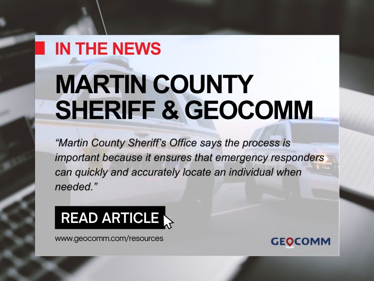
Martin County Sheriff’s Office Launches Project to Enhance 9-1-1 Services
MARTIN COUNTY, Fla. (CBS12) — A project is underway to improve 911 emergency response services in Martin County. The Martin County Sheriff’s Office (MCSO) says that from Wednesday to February 3, deputies, including field technicians from the firm GeoComm, will visit certain Martin County homes to confirm addresses and street names. A map provided by...

ZeroEyes and GeoComm Partner to Enhance Iowa School Safety with Advanced AI Gun Detection and Intelligent Mapping
ZeroEyes, the creators of the only AI-based gun detection video analytics platform that holds the US Department of Homeland Security Safety Act Designation, and GeoComm, the provider of locally authoritative indoor and outdoor Geographic Information Systems (GIS), today announced a technology integration partnership to enhance emergency response and school safety. This collaboration merges ZeroEyes' AI gun detection and situational awareness software with GeoComm's comprehensive indoor mapping solutions to provide real-time, actionable intelligence to any Iowa K-12 schools.

Unlocking the Power of Map Data Manager: Enhancing School Safety & Indoor Safety
An indoor map delivers the next level of precise location information via a highly organized visualization of all the essential elements in a building. Bringing your building to life with a detailed map and into the hands of those who need it is a critical first step to unlocking seamless navigation and enhanced accessibility!

Superior Software Maintenance with Cloud-Native Public Safety Applications
As an administrator of your agency's public safety information technology infrastructure, you are responsible for coordinating minimal impact updates on your critical software applications. This can sometimes require careful planning and scheduling due to the time-sensitive updates and software patches which need immediate attention. What if you could eliminate the interruption and get these enhancements to users sooner? Cloud-native applications to the rescue.

Webinar Recap: Embarking on your NG9-1-1 GIS Migration
On Friday, March 5, 2021, GeoComm hosted a webinar titled, “Embarking on your NG9-1-1 GIS Migration.” GeoComm’s Jessica Frye, ENP, GIS Project manager and Kathy Liljequist, GIS Consultant offered attendees the opportunity to learn more about critical GIS data maintenance workflow decisions that 9-1-1 and GIS departments face as they embark on the NG9-1-1 GIS migration.

2020 Year in Review
2020 was a year that changed the world, creating unique and stressful situations for everyone. We know frontline workers faced many additional obstacles throughout the uncertain time, and we remain grateful for their ongoing commitment and dedication to helping the communities they serve.
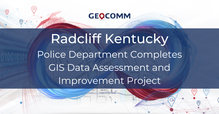
Radcliff Kentucky Police Department Completes GIS Data Assessment and Improvement Project
In 2020 GeoComm worked with the Radcliff Kentucky Police Department, to review the current state of the GIS data being used being utilized at their ECC. This project utilized GeoComm’s proven assess, improve, maintain approach for achieving public safety grade GIS data, ensuring its accuracy for routing emergency response through their CAD system.

Webinar Recap: Advancing Location Intelligence: Accessing Indoor Maps from RapidSOS Portal
On Tuesday, December 8th, 2020, GeoComm and RapidSOS hosted a webinar titled Advancing Location Intelligence: Accessing Indoor Maps from RapidSOS Portal. GeoComm's John Brosowsky, Vice President of Innovation and RapidSOS' Karin Marquez, Senior Director of Public Safety sat down to discuss: why now is the right time to equip 9-1-1 call takers and emergency responders with indoor location intelligence, the value indoor maps offer when combined with improved 9-1-1 caller location coordinates and Esri’s industry-leading mapping technology, and how to leverage location intelligence through RapidSOS Portal to create unprecedented situational awareness.

GeoComm By The Numbers
We know that in an emergency every second counts and have spent the last 25 years helping our customers save lives and protect property by providing essential, innovative, location-based solutions to public safety professionals.
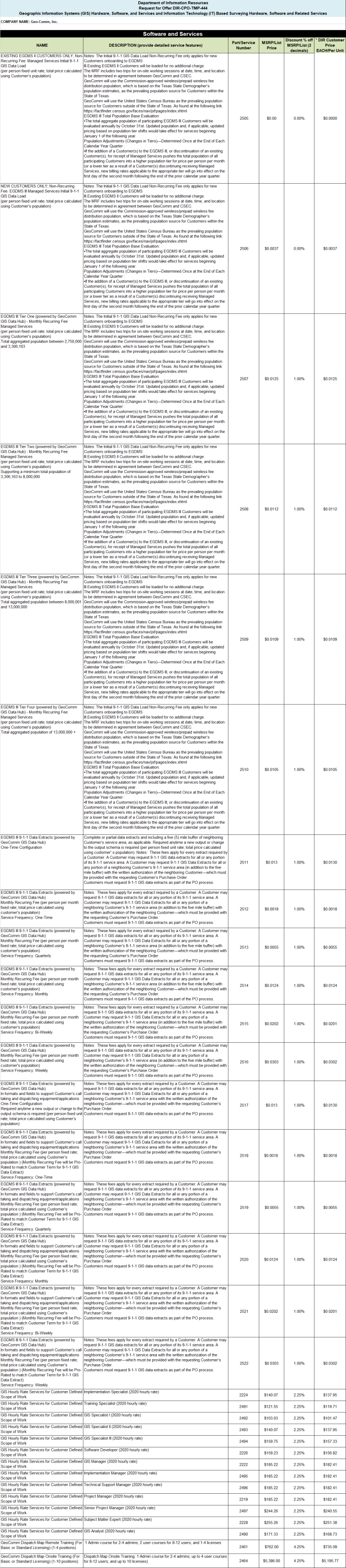
2020 Texas DIR Contract and Pricing
GeoComm, a leading provider of geographic information and communication systems, has been awarded a Texas Department of Information Resources (DIR) contract DIR-TSO-3441 for GeoComm’s public safety software.
Innovation Spotlight~ Automated External Defibrillator Location Display Experience
GeoComm partnered with Stearns County, Minnesota, and a local non-profit in 2019 on an initiative aimed at mapping the location information for Automatic Emergency Defibrillators (AEDs) in Stearns County. The goal of the project was to empower 9-1-1 PSAPs with AED location information so PSAP call takers could inform 9-1-1 callers of nearby AED locations....

Understanding The Urgency For Indoor Maps
Today, most people expect that 9-1-1 call centers can pinpoint their exact location during emergency calls, even inside of buildings. But you do not have to look far to find high profile cases where challenges locating 9-1-1 callers indoors have contributed to increased emergency response times, and even tragic outcomes.