Latest GeoComm updates
AI Needs GIS
By John Brosowsky, SVP of Innovation, GeoComm Artificial intelligence is rapidly reshaping PSAP operations. From handling non-emergency calls to enabling real-time 9-1-1 transcription, translation, keyword detection, and call taker assistance, AI is becoming an integral part of modern emergency communications. But AI is not inherently intelligent; it identifies patterns and relationships within the information it has been trained on...

GeoComm and geoConvergence Announce Partnership to Support the Future of Indoor Mapping
Partnership highlights the increasing role of accurate indoor maps, GIS data, and public safety grade location intelligence in emergency response, school safety, and facility operations. ST. CLOUD, Minn., July 10, 2026 /PRNewswire/ — GeoComm, the nation’s leader in public safety grade location intelligence, today announced a new partnership with geoConvergence, a GIS consulting firm based in Bloomington, Indiana....

GeoComm Launches Map Converter to Accelerate the Conversion of Static Floorplans into Response Ready Indoor GIS Data
New public safety grade solution accelerates static floorplan-to-GIS conversion, helping public safety, school safety, healthcare, and critical infrastructure organizations improve situational awareness, coordination, and response readiness ST. CLOUD, Minn. – June 24, 2026 – GeoComm, leading provider of public safety grade location data and mapping solutions, today announced GeoComm Map Converter, a new solution designed to help organizations...

GeoComm Providing Indoor Maps Offering, a Key Element of Public Safety Location Intelligence™
GeoComm, a leading provider of public safety GIS systems, is excited to offer Indoor Mapping services aimed at empowering law enforcement, fire, and medical responders by providing a visual representation of indoor spaces for key buildings in their response areas.
Announcing Public Safety Location Intelligence™ from GeoComm
GeoComm, an industry leading provider of public safety GIS, is excited to announce the release of a new website highlighting the need for Public Safety Location Intelligence™ in 9-1-1 emergency response. Today public safety GIS data and location information is disparate, inconsistent, and expanding. Public Safety Location Intelligence from GeoComm provides a new way to get the right location information, on the right map, for the right people, at the right time, in order to respond to emergency calls faster.

GeoComm’s Jody Sayre Named To Esri’s Partner Advisory Network
GeoComm today announced the nomination and acceptance of Jody Sayre to Esri’s Partner Advisory Council (PAC). Jody Sayre, GeoComm’s Vice President of Marketing and Channel Management will serve as a representative for a 3-year term. By participating on the PAC, Jody will represent and advocate for the needs of current and potential GeoComm public safety customers that utilize Esri ArcGIS Platform technologies in mission critical life-saving applications.
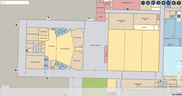
Esri, GeoComm, RapidSOS Partner to Bring Indoor Maps to First Responders
Location is the most important piece of information in an emergency. With over 80 percent of 911 calls coming from cell phones—many of them from citizens located indoors—it is critical that first responders have accurate information on where incidents are occurring. This partnership provides accurate caller location and other critical data through the context of indoor maps, creating an advanced view of the emergency.

Public Safety Industry Professional Joins GeoComm’s Product Management Team
GeoComm is excited to announce the addition of Dan Craigie to the Product Management Team serving as the Business Development Program Manager. Dan was most recently the 9-1-1 Program Manager for Emergency Communication Networks Division at the Minnesota Department of Public Safety and has first-hand experience understanding the challenges public safety agencies face today.

GeoComm’s Commitment to Local Community Remains Strong in 2020
The current COVID-19 pandemic has changed the world, creating unique and stressful situations for everyone. Throughout this uncertain time, we feel fortunate that our employees have been able to work remotely while still providing the highest level of service that our customers have come to expect. In addition to our customer dedication, we are also committed to being responsible corporate citizens and giving back to our local community.
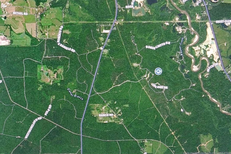
Washington Parish, Louisiana Utilizes GeoComm Dispatch Map to Help Locate Lost Hiker
Washington Parish Louisiana Communications District is dedicated to providing the most accurate and current 9-1-1 equipment in their emergency communications center. That dedication proved to be a wise investment when they received a 9-1-1 call from a hiker in the Bogue Chitto State Park who had gotten lost on one of the trails in the woods.

State of Wisconsin Selects GeoComm for Statewide NG9-1-1 GIS Project
GeoComm is excited to announce they have been selected by the State of Wisconsin to complete a Next Generation 9-1-1 (NG9-1-1) GIS Consulting Project. As the State of Wisconsin transitions to a NG9-1-1 environment, the need for a robust GIS environment at local, regional, and statewide agencies dramatically increases.

GeoComm Celebrating Twenty-Five Years of Empowering Our Customers to Create Powerful 9-1-1 and NG9-1-1 System Public Safety Grade GIS Data
When founded in 1995, GeoComm provided turnkey emergency services to local county governments and throughout the years has grown to not only serve local county governments but also, regional and statewide government agencies as well as some military agencies spanning forty-nine different states, protecting more than 100 million people.
