Latest GeoComm updates

GeoComm and StrataSite Partner to Help Schools Strengthen Preparedness and Improve Coordinated Response
Partnership connects trusted indoor mapping with coordinated response planning, training, and readiness tools to help schools and emergency responders align faster, reduce confusion, and act with greater confidence. ST. CLOUD, Minn., May 19, 2026 /PRNewswire/ — GeoComm, the provider of public-safety-grade location intelligence that underpins critical incident response, and StrataSite, a collaborative incident action planning solution, today...

How New Mexico Strengthened Emergency Response with Public Safety Grade GIS Data
Ensuring Accurate Location Data Across 100+ Local Governments. Overview In New Mexico, a largely rural state with vast geographic areas and limited emergency resources, even small GIS data errors can have life-threatening consequences. With more than 100 local government agencies contributing GIS data and over 40 Public Safety Answering Points (PSAPs) relying on that data...

GeoComm Indoor Mapping Integration with Zetron Help Strengthen Iowa Public Safety Response
Integration brings indoor building context into Zetron workflows to help public safety teams respond faster, coordinate more effectively, and improve situational awareness during indoor emergencies across Iowa. St. Cloud, Minn. – April 28, 2026 – GeoComm today announced an integration that brings GeoComm indoor mapping content into Zetron’s Map Viewer, helping support public safety agencies...

RapidDeploy Announces Lightning Partner Program to Create End-to-End Cloud Safety Ecosystem
RapidDeploy, the leader in Cloud Aided Dispatch software for emergency communications centers, announces the launch of its Lightning Partner Program. The Program creates an integrated end-to-end ecosystem of visionary technology partners who believe in democratizing public safety utilizing cloud native technology. The solutions, integrated across Microsoft’s Azure Government cloud, will provide a comprehensive platform for public safety agencies.

Berkeley County, WV: Recognizing the Value of Data Management Software for Consistent and Quality GIS Data
Jeff Frye from Berkeley County West Virginia Department of Information Technology recently shared with us his experience using GeoComm Maintainer, an NG9-1-1 GIS addressing tool, to achieve high levels of accuracy and synchronization of their geospatial 9-1-1 data.
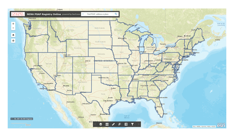
NENA: The 9-1-1 Association Develops New Database Tool to Help 9-1-1 Centers Save Lives in Partnership with GeoComm, Esri, and Uber
NENA and GeoComm are pleased to announce the development of the new Enhanced Public Safety Answering Point (PSAP) Registry and Census (EPRC), a secure web-based tool containing essential information for PSAPs throughout the United States. The NENA EPRC, made possible through a sponsorship from Uber, will replace and improve upon NENA’s current PSAP Registry, which is a basic database of the contact information for every 9-1-1 center in the nation.
Webster County, Mississippi Selects GeoComm Dispatch Map For New Dispatch Mapping Software
When there is an emergency, time is everything. That is why 9-1-1 centers are always working to improve emergency response times. Webster County, Mississippi was working to do just that when they installed GeoComm Dispatch Map.

GeoComm Adds to Product Management Team, Expands Industry Leadership in Geospatial Call Routing
GeoComm is pleased to announce the addition of Lisa Henderson as the Senior Product Manager for Next Generation 9-1-1 (NG9-1-1) Core Solutions focusing specifically on the geospatial solutions needed in a NG9-1-1 Environment.

GeoComm Secures Spot on HGACBuy Contract Through 2020
GeoComm is pleased to announce their public safety GIS software and services have been accepted onto the Houston Area Council Buy (HGACBuy) contract. HGACBuy is an established contract for goods and services dedicated to helping governments across the country improve the efficiency of their procurement process.

GeoComm Reaches Important Milestone, Celebrates Twenty Year Parntership with Esri
GeoComm is excited to have reached an important twenty years of a dedicated partnership milestone with Esri. This partnership demonstrates two decades of commitment to designing, developing, and leveraging the Esri ArcGIS software platform in our public safety GIS applications.

RapidSOS and GeoComm Partner to Provide Accurate Location and Enhanced Data to 9-1-1 Centers using GeoComm Mapping Systems
GeoComm and RapidSOS are pleased to announce a strategic partnership to provide public safety agencies that use GeoComm 9-1-1 Public Safety Answering Point (PSAP) mapping systems with accurate location and additional data from the RapidSOS Clearinghouse. Through this partnership, PSAP’s working with GeoComm will be able to harness data from the RapidSOS NG911 Clearinghouse — including accurate handset location from all smartphone location sensors natively embedded into the 9-1-1 call flow.