Latest GeoComm updates

AI Needs GIS
By John Brosowsky, SVP of Innovation, GeoComm Artificial intelligence is rapidly reshaping PSAP operations. From handling non-emergency calls to enabling real-time 9-1-1 transcription, translation, keyword detection, and call taker assistance, AI is becoming an integral part of modern emergency communications. But AI is not inherently intelligent; it identifies patterns and relationships within the information it has been trained on...

GeoComm and geoConvergence Announce Partnership to Support the Future of Indoor Mapping
Partnership highlights the increasing role of accurate indoor maps, GIS data, and public safety grade location intelligence in emergency response, school safety, and facility operations. ST. CLOUD, Minn., July 10, 2026 /PRNewswire/ — GeoComm, the nation’s leader in public safety grade location intelligence, today announced a new partnership with geoConvergence, a GIS consulting firm based in Bloomington, Indiana....

GeoComm Launches Map Converter to Accelerate the Conversion of Static Floorplans into Response Ready Indoor GIS Data
New public safety grade solution accelerates static floorplan-to-GIS conversion, helping public safety, school safety, healthcare, and critical infrastructure organizations improve situational awareness, coordination, and response readiness ST. CLOUD, Minn. – June 24, 2026 – GeoComm, leading provider of public safety grade location data and mapping solutions, today announced GeoComm Map Converter, a new solution designed to help organizations...
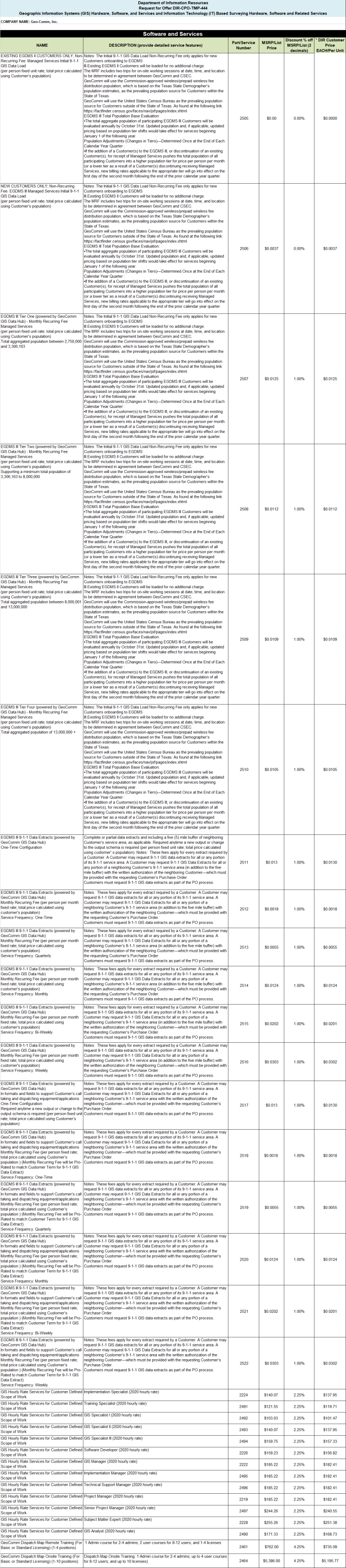
2020 Texas DIR Contract and Pricing
GeoComm, a leading provider of geographic information and communication systems, has been awarded a Texas Department of Information Resources (DIR) contract DIR-TSO-3441 for GeoComm’s public safety software.

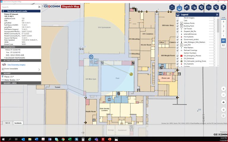
Innovation Spotlight~ Automated External Defibrillator Location Display Experience
GeoComm partnered with Stearns County, Minnesota, and a local non-profit in 2019 on an initiative aimed at mapping the location information for Automatic Emergency Defibrillators (AEDs) in Stearns County. The goal of the project was to empower 9-1-1 PSAPs with AED location information so PSAP call takers could inform 9-1-1 callers of nearby AED locations....

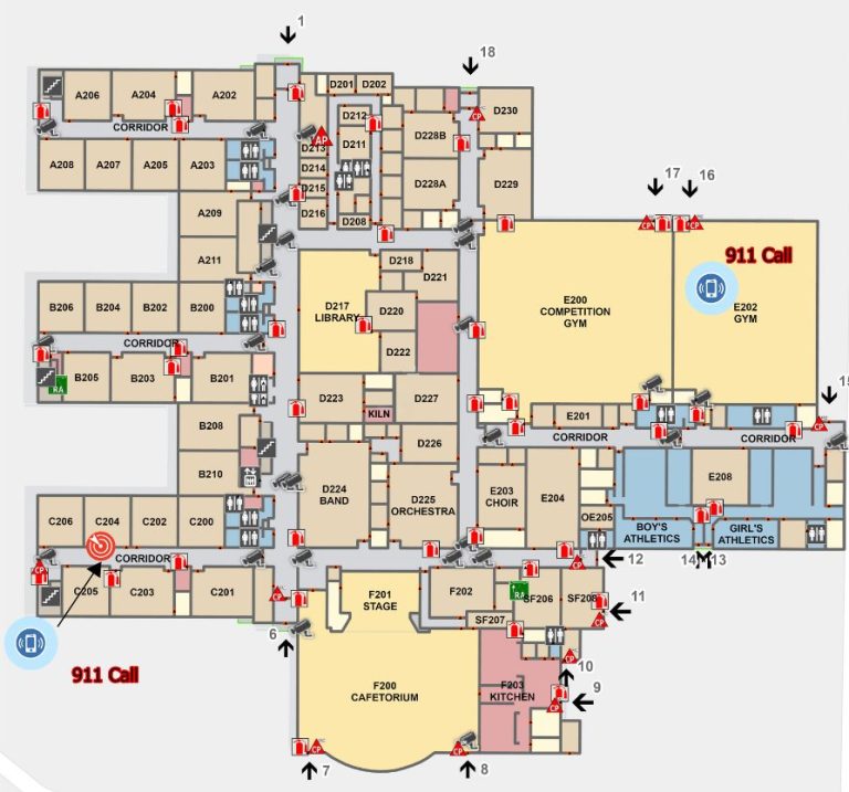
Understanding The Urgency For Indoor Maps
Today, most people expect that 9-1-1 call centers can pinpoint their exact location during emergency calls, even inside of buildings. But you do not have to look far to find high profile cases where challenges locating 9-1-1 callers indoors have contributed to increased emergency response times, and even tragic outcomes.
Indoor Mapping: Why do I need it?
By now you have probably heard the statistic that today approximately 80 percent of all 9-1-1 calls originate from mobile phones. More and more people are forgoing wireline telephone service and are relying on mobile phone service exclusively. Indoor maps are needed to fully unlock the life-saving potential of indoor geodetic positions of mobile phones during 9-1-1 calls that the industry has worked so hard for to create.

El Paso – Teller County 9-1-1 Authority Achieves Improved, Dependable, and Compliant GIS Data
These three words describe the current condition of El Paso-Teller County 9-1-1 Authority's GIS data. This is a drastic change from how it would have been described in 2016.
North Texas Emergency Communications Center
The North Texas Emergency Communications Center (NTECC) formed in 2014 by the four cities they serve, the cities of Carrollton, Coppell, Farmers Branch and the Town of Addison. The NTECC provides a high level of police, fire, and EMS services to the 250,000 residents and visitors they serve.

Customer Feature: Denco Area 9-1-1 District
The Denco Area 9-1-1 District (Denco) is an emergency communication district in Texas that utilizes multiple GeoComm software solutions to overcome their unique GIS data obstacles and empower themselves with tools that simplify the completion of their daily GIS processes.
2019 Texas DIR Contract and Pricing
GeoComm, a leading provider of geographic information and communication systems, has been awarded a Texas Department of Information Resources (DIR) contract DIR-TSO-3441 for GeoComm’s public safety software.
Innovation Spotlight ~ Smarter Security Provided Through Indoor Maps and Sensor Feeds
In 2017, GeoComm worked with U.S. Bank Stadium and the Minneapolis Police Department to deploy and innovative new software to be used in the ESPN XGames that provided real-time information and sensor feeds into a Common Operating Picture (COP) built around 3D and indoor maps. The system was again used in 2017 during the Twin...