Life-Saving Z-Axis Data in the Emergency Communication Center
When a 9-1-1 call is placed, the caller’s location is a primary piece of information that dispatchers need to deploy emergency response personnel. Where is the caller located? What do their surroundings look like? Could something about that location be an obstacle or even hazardous to first responders?
However, as mobile phones have become a primary form of communication in the U.S., accurately identifying a 9-1-1 caller’s location has become more difficult. The National Emergency Number Association (NENA) reports that 80% or more of 9-1-1 calls are made from wireless devices, yet location coordinates from those devices in the past have been notoriously inexact when the caller is inside of a building – ultimately adding precious seconds, minutes, or more to emergency response times. Fortunately, new FCC regulations and new technology have emerged that are making mobile phone positioning during 9-1-1 calls much more accurate and precise. One element of this new positioning technology is to place the caller’s location vertically—on the Z-axis.
“The new technology for determining z-axis is critical especially when a 9-1-1 caller can’t speak or communicate their exact location (such as due to the nature of the emergency), and when no one else is around to help flag down help,” said John Brosowsky, Vice President of Innovation at GeoComm
Why is Z-Axis Important for 9-1-1 Calls?
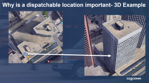
Emergency Communication Centers (ECCs) have had access to latitude and longitude coordinates from mobile phone callers for some time, but latitude and longitude coordinates alone don’t provide the complete picture to 9-1-1 telecommunicators, dispatchers, and emergency responders. The vertical dimension – also known as the z-axis – is essential for finding a caller within a multi-story building. For example, a 9-1-1 telecommunicator seeing that a mobile phone caller is in the southwest corner of a building is not the entire picture if they don’t also know that the caller is on the 10th floor of the building.
The accurate and precise locations of 9-1-1 callers, including inside buildings and including in the Z-axis, is critical for responding quickly and saving lives. In 2015, the FCC instructed U.S. wireless carriers to begin providing z-axis location to Emergency Communications Centers (ECCs) by 2021. Today, the carriers must deliver the z-axis location data within +/- 3 meters for 80 percent of calls and report the uncertainty value for calls.
How should the new Z-Axis caller location information be interpreted at the ECC?
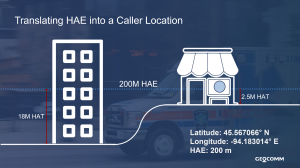
While the new z-axis location information is incredibly powerful, unfortunately interpreting it correctly and making it actionable isn’t as simple as just reading a number off the 9-1-1 call ALI display. The vertical measurement is provided as a Height Above Ellipsoid, or HAE.
HAE is a measure of the distance from a point in space from a mathematical model of the earth’s surface as if it were a perfect ellipsoid. It’s easier to calculate using the data available on mobile hardware, but since earth has hills, valleys, and mountains, we can’t be told a figure for HAE and know what to do with it. At the same HAE, one person might be on the 3rd floor, and just blocks away, somebody else might be on the first floor.
An actionable vertical location depends on GIS knowledge of ground elevation and features at a location. GeoComm Vertical Location Services makes it easy for partners, and ultimately telecommunicators and first responders, to quickly gain access to this life-saving technology to create a dispatchable location that includes estimated floor level, height above terrain, street address, and building information.
In November 2022, GeoComm announced their GeoComm Vertical Location Services partner offering for any Computer Aided Dispatch (CAD), 9-1-1 telephony, and other ECC systems. Vertical Location Services is designed for an easy integration so that partners can quickly deliver this valuable information to customers.
About GeoComm
GeoComm, provider of Public Safety Location Intelligence®, serves local, regional, statewide, and military agencies in forty-nine states, helping keep more than 100 million people safe. Over the last 27 years, GeoComm’s public safety GIS systems have routed emergency calls to the appropriate 9-1-1 call centers, mapped callers’ locations on tactical emergency response mapping displays, and guided emergency responders to accident scenes on in-vehicle mapping and navigation applications within police, fire, and ambulance vehicles. In addition, our statewide NG9-1-1 GIS project footprint has expanded to include 17 statewide projects across the country. Visit www.geocomm.com to learn more about GeoComm and our Public Safety Location Intelligence® offerings.


