
Visualize Emergency Calls
- Enhance Location Accuracy Convert vertical location elevation data into actionable locations, including building names, floor levels, and street addresses for precise 9-1-1 responses.
- Seamless System Integration Integrate with public safety systems like dispatch mapping and computer-aided dispatch to streamline emergency response workflows.
- Utilize Indoor Maps Leverage indoor maps and surveyed building data to improve vertical location precision, ensuring reliable dispatchable locations for emergency responders.
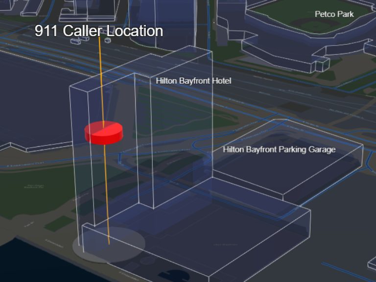
Improve Emergency Response with Vertical Location Services
Learn how GeoComm Vertical Location Services enhances 9-1-1 accuracy.
Resources

AI Needs GIS
By John Brosowsky, SVP of Innovation, GeoComm Artificial intelligence is rapidly reshaping PSAP operations. From handling non-emergency calls to enabling real-time 9-1-1 transcription, translation, keyword detection, and call taker assistance, AI is becoming an integral part of modern emergency communications. But AI is not inherently intelligent; it identifies patterns and relationships within the information it has been trained on…

GeoComm and geoConvergence Announce Partnership to Support the Future of Indoor Mapping
Partnership highlights the increasing role of accurate indoor maps, GIS data, and public safety grade location intelligence in emergency response, school safety, and facility operations. ST. CLOUD, Minn., July 10, 2026 /PRNewswire/ — GeoComm, the nation’s leader in public safety grade location intelligence, today announced a new partnership with geoConvergence, a GIS consulting firm based in Bloomington, Indiana….

FCC’s NG9-1-1 Reliability and Interoperability Initiative: Why It Matters and What it Means for GIS and Location Data
The Federal Communications Commission’s ongoing efforts to strengthen Next Generation 9-1-1 (NG9-1-1) reliability and interoperability represent an important step toward ensuring that emergency communications systems can meet the needs of communities across the United States. As NG9-1-1 deployments continue to expand, the industry’s focus must extend beyond simply connecting networks. True interoperability requires consistent, reliable, and trusted location data and maps that…