How 9-1-1 Vertical Location Accuracy Is Transforming 9-1-1 Response
What happens when you call 911 from your mobile phone inside a multi-story building? Accurate 9-1-1 vertical location accuracy becomes the difference between a rapid rescue and a costly delay.
Until recently, unless you or others could verbally tell emergency responders what floor you were on, it was very difficult for them to find you quickly. This could delay critical emergency response when seconds and minutes matter the most.
Fortunately, new FCC rules and mobile phone location technologies have emerged that can help. The rules specify when and where carriers must determine vertical (z-axis) information about your phone and transmit it into the 9-1-1 system.
So, problem solved right? Not so fast. The vertical positions sent to the 9-1-1 system are raw numerical measurement in the form of XYZ coordinates like: latitude 35.6762, longitude -82.2724, and Height Above Ellipsoid (HAE) 914.1211. No emergency responder can look at those numbers and know right where to go.
Height Above Ellipsoid (HAE) requires additional translation to become actionable for emergency response. The example below shows two adjacent buildings. A 9-1-1 call reporting a vertical HAE of 200 meters could be on the 4th floor of the building on the left, but that same HAE of 200 meters maps to the first floor of the building on the right!
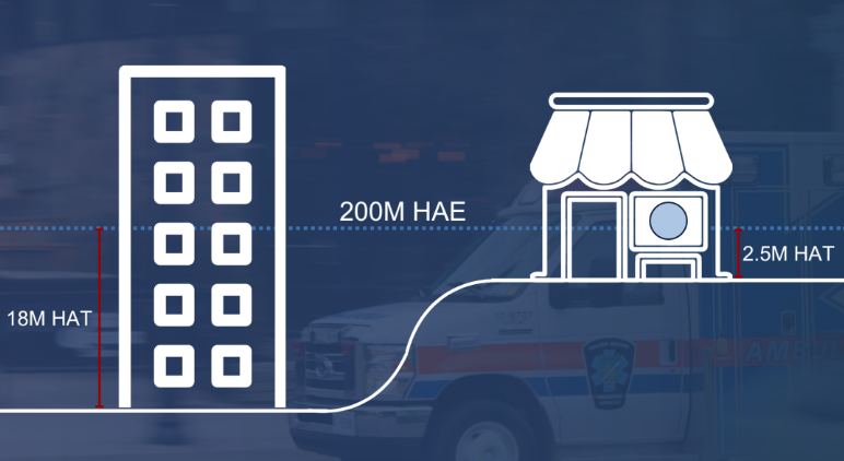
Local GIS data is required to accurately convert z-axis vertical HAE measurements of 9-1-1 callers into dispatchable information such as floor number in a building.
That’s where local 9-1-1 authorities and PSAPs have a role to play. Local authorities can build and maintain local GIS data that includes information about building heights and floor surveyed floor level altitudes. This information is critical for converting those raw XYZ coordinates into hyper-accurate dispatchable location information including street address, building name, and building floor number.
How can GeoComm Delivers True 9-1-1 Vertical Location Accuracy? GeoComm can help in two ways.
First, our Vertical Location Services can empower 9-1-1 PSAPs to visualize vertical caller location, and estimate floor levels for any location in the country.
Tip: Check your PSAP mapping apps to see if they already have access to GeoComm VLS during wireless 9-1-1 calls. If not, reach out to your PSAP software vendors to request access.
And second, GeoComm has indoor mapping products and services for mapping buildings in your jurisdiction, including capturing information such as building heights and floor level altitudes. This detailed GIS data can enable GeoComm’s VLS to provide the absolute highest accuracy of reported floor level during wireless 9-1-1 calls inside buildings, which is much better than floor level estimates.
GeoComm’s Vertical Location Services and indoor mapping solutions give public safety agencies the tools they need to make that translation possible—turning complex XYZ coordinates into precise, life-saving location information.
Ready to take vertical location accuracy to the next level?
Contact us to see how we can support your agency with true 9-1-1 vertical location accuracy at your team’s fingertips.