School Safety Mapping Data: What West Virginia’s HB 3166 Means for Your District
In an era where school safety is paramount, West Virginia has taken a significant step forward with the passage of House Bill 3166 (HB 3166). This legislation mandates the creation of standardized school safety mapping data across all public schools in the state. As a leader in public safety GIS solutions, GeoComm is poised to assist educational institutions in meeting these new requirements efficiently and effectively.
Understanding HB 3166: Key Requirements
Enacted during the 2025 Regular Session, HB 3166 amends the West Virginia Code by adding §18-9F-10a, focusing on standardized school safety mapping data. The bill stipulates that each county board of education must establish such data before September 1, 2025. The mapping data must adhere to specific criteria:
- Compatibility and Accessibility: Data must integrate with existing software platforms used by public safety agencies without requiring additional software purchases or access fees.
- Versatile Formats: Maps should be printable, shareable electronically, and, if requested, compatible with interactive mobile platforms.
- Open-Source Accessibility: Data must be viewable and printable from open-source document or image viewers.
- Standardized Orientation: Maps should be oriented to true north and include a grid with “x” and “y” coordinates.
- Verified Accuracy: Accuracy must be confirmed through on-site walk-throughs of school buildings and grounds.
- Detailed Floor Plans: Maps should include accurate floor plans overlaid on current, verified aerial imagery of the school campus.
- Comprehensive Labeling: Site-specific labels for structures, room names, hallway designations, exterior doors, stairwell numbers, hazard locations, utility controls, key boxes, automated external defibrillators, trauma kits, parking areas, athletic fields, surrounding roads, and neighboring properties must be included.
The finalized school safety mapping data is to be provided to the state board of education, Division of Homeland Security and Emergency Management, and local first response agencies, including police, fire, and EMS, at no cost beyond the initial production.
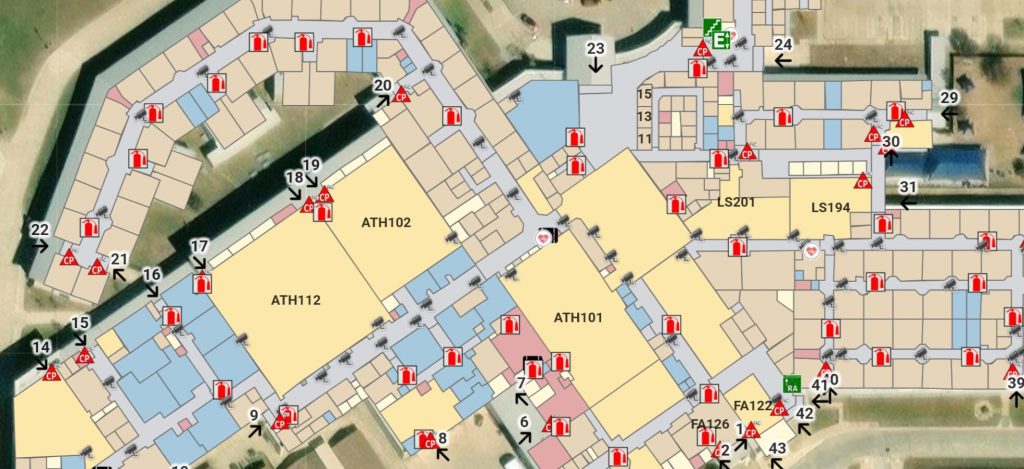
GeoComm School Safety map highlighting key indoor features to enhance emergency response and preparedness.
Fiscal Implications
The West Virginia State Board of Education estimates the total educational space requiring mapping at approximately 13.5 million square feet. Using a cost-per-square-foot method, the estimated expense for creating the standardized safety mapping plans is $0.35 per square foot, totaling around $4.725 million. This estimate covers the initial creation of the school safety mapping data and does not include costs associated with data storage or access management.
GeoComm’s Role in Supporting School Safety Mapping Data Compliance with West Virginia’s HB 3166
GeoComm specializes in public safety GIS solutions, offering comprehensive services that align seamlessly with the requirements set forth in HB 3166. Our expertise includes:
- Data Integration: Ensuring compatibility with existing public safety software platforms.
- Accurate Mapping: Providing detailed floor plans and site-specific labeling through verified on-site assessments.
- Open-Source Solutions: Delivering data in formats accessible through open-source viewers.
- Comprehensive Coverage: Including all necessary details from room names to external facilities and neighboring properties.
By partnering with GeoComm, schools can efficiently meet HB 3166 mandates, ensuring enhanced safety and preparedness.
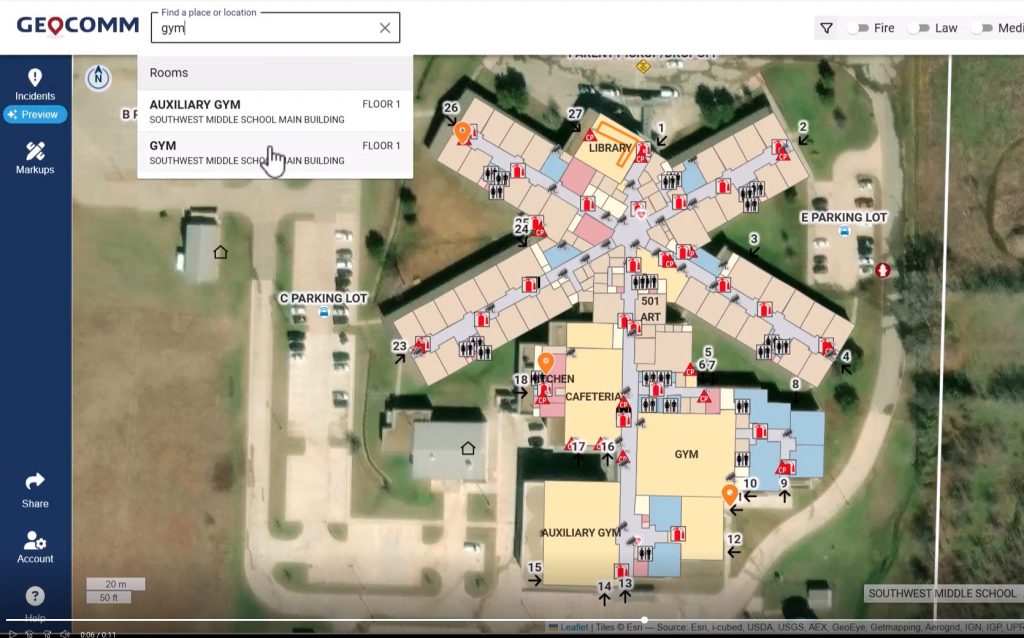
An advanced digital mapping system enhancing school safety by providing GIS-based interactive navigation, emergency response planning, and real-time location search
Next Steps for Educational Institutions West Virginia Legislature
With the September 1, 2025, deadline approaching, it’s imperative for county boards of education to initiate the process of developing standardized school safety mapping data. Engaging with experienced GIS professionals like GeoComm can streamline this process, ensuring compliance and bolstering the safety infrastructure of educational facilities.
For more information on how GeoComm can assist your institution in meeting HB 3166 requirements, please contact us.
Recommended additional reading:
Learn how GIS data transformed school mapping & 9-1-1 emergency response in Southwest Minnesota
Having a hard time identifying a school safety mapping data vendor? Here are 15 Must-Ask Questions to Choose the Best Mapping Vendor