
Visualize Emergency Calls
- Enhance Location Accuracy Convert vertical location elevation data into actionable locations, including building names, floor levels, and street addresses for precise 9-1-1 responses.
- Seamless System Integration Integrate with public safety systems like dispatch mapping and computer-aided dispatch to streamline emergency response workflows.
- Utilize Indoor Maps Leverage indoor maps and surveyed building data to improve vertical location precision, ensuring reliable dispatchable locations for emergency responders.
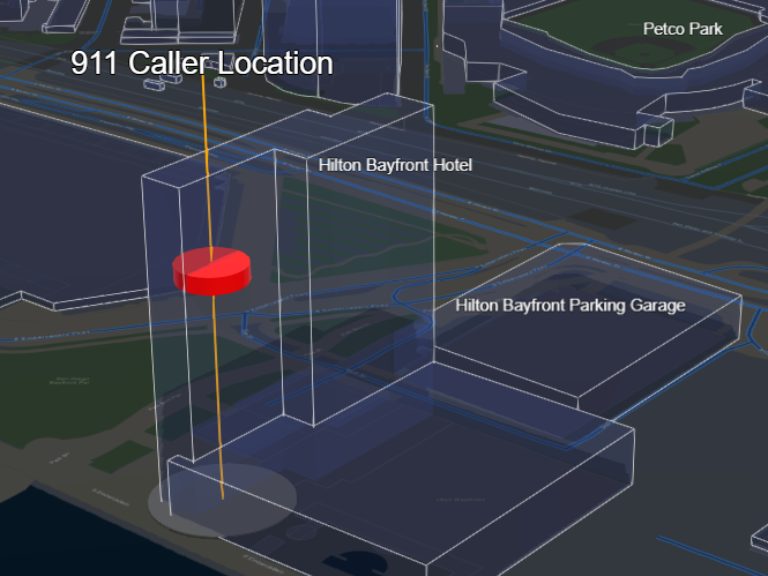
Improve Emergency Response with Vertical Location Services
Learn how GeoComm Vertical Location Services enhances 9-1-1 accuracy.
GIS Resources

Bixby Public Schools Strengthens Emergency Preparedness With GeoComm’s School Safety Mapping Technology
St. Cloud, MN, February 16, 2026: Bixby Public Schools in Bixby, Oklahoma has partnered with GeoComm to implement districtwide school safety mapping across its 10 campuses, covering over 1.7 million square feet and supporting over 7,000 students. As one of the fastest -growing school districts in the state, Bixby Public Schools faced growing complexity in…

GeoComm Featured on WHO 13 News: Advancing School Safety in Iowa
Iowa schools are strengthening emergency preparedness with advanced 9-1-1 mapping and call-forwarding technology designed to give first responders faster, clearer situational awareness when every second matters. Through the statewide Critical Incident Mapping initiative, more than 1,400 schools across Iowa now have access to accurate, up-to-date indoor maps that support improved communication between school staff, 9-1-1…
2026 Texas DIR Contract and Pricing
GeoComm, a leading provider of geographic information and communication systems, has been awarded a Texas Department of Information Resources (DIR) contract DIR-CPO-4499 for GeoComm’s public safety software.