Indoor Maps vs. Floor Plans: 5 Reasons They’re Critical for Public Safety
Merriam-Webster’s Dictionary defines a floor plan as “a scale diagram of a room or suite of rooms viewed from above” and a map as “ a flat surface of the whole or a part of an area.” But in the world of emergency response and public safety, what separates a traditional floor plan from a modern, intelligent indoor map?
Similarities. There are many similarities between floor plans and indoor maps:
Both floor plans and indoor maps are simplified generalizations of reality, each depicting or highlighting only the information needed by end-users for accomplishing specific goals such planning effective use and furniture placement or navigating from point A to point B inside a building.
Indoor maps can cover the same indoor spaces as floor plans. Both indoor maps and floor plans are often used in public safety applications.
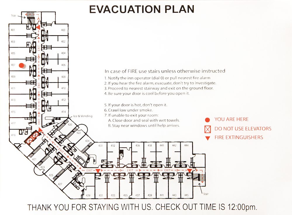
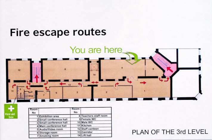
For example, many hotels post floor plans showing fire exits, while indoor maps are increasingly powering 9-1-1 systems, mobile safety apps, and emergency response platforms.
5 Key Differences: Indoor Maps vs. Floor Plans
To fully understand the advantages of indoor maps, especially in critical situations, here are the five most important differences.
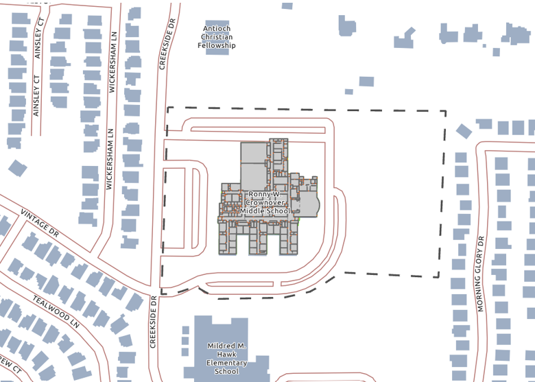
#1: Indoor maps show the location of sites, buildings, units, floors, rooms and other indoor spaces in relation to the rest of the world.
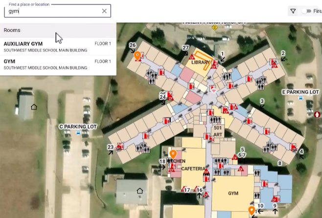
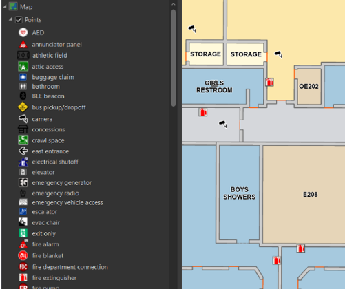
#2: Indoor maps can be searched by room number, type, occupant information, and other attributes.
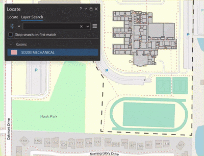
#3: Indoor maps are dynamic and can change display at different map scales and rotations in order to always be clearly visible and readable:
#4: Indoor maps are routable and can be used for wayfinding, navigation, and indoor positioning of moving assets inside buildings.
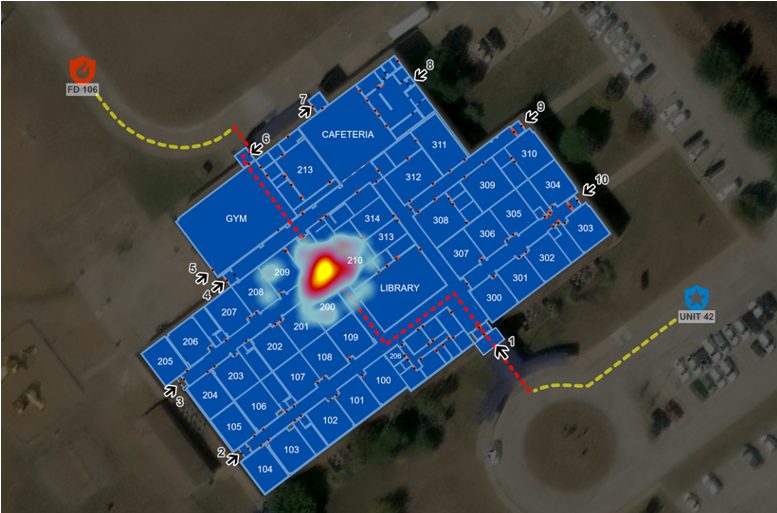
The dynamic digital and geo-referenced nature of indoor maps enables:
- Automatically displaying the correct floor of the building to responders
- Displaying surrounding map information such as streets and aerial imagery
- Displaying sensor feed information from inside the building such as alarm status and room occupancy counts
- Displaying the current location of responders navigating to the scene
- Providing outdoor and indoor routes to get responders to the scene as quickly as possible
This type of dynamic real-time information display is not possible with static floor plans and printed documents in binders.
#5: Indoor maps are easier to update, and the same indoor maps can be re-used for multiple different types of end-user applications.
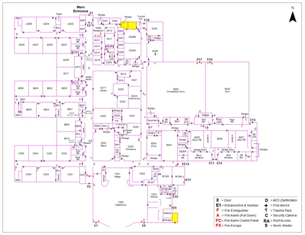
Because indoor maps are digital GIS map layers, they may be rendered in different ways to highlight different information for different users, without modifying or re-generating the underlying indoor map data. For example, emergency responders may be most interested in map elements such as building access locations, room names and numbers, and fire control and alarm panel locations. A facilities manager may be more interested in physical equipment location and inspection and replacement status and schedule. Both of those use cases can be accommodated by the same indoor map.
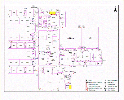
In contrast, an evacuation floor plan printed onto a metal placard and mounted onto a wall of a hotel next to an elevator has only a single purpose such as presenting occupants with information about how to exit the floor during a fire. The same evacuation floor plan printed onto a metal placard cannot be used for space planning or furniture placement for example.
Finally, it’s important to note that buildings change over time. Additions and remodeling change building layouts, and changes in uses for indoor spaces can impact room names and numbers. Digital GIS indoor map layers are easier to update, and when updated all end-user applications the indoor maps are streamed to automatically see the updates.
In contrast, floor plans, especially in printed documents, need to be recreated, reprinted, and physically shipped and received by end users for the floor plan updates to be realized. This can be time-consuming and makes it difficult to ensure that all users are looking at the same version of the floor plan at the same time. This in turn can increase response times and create confusion and inefficiency during emergency responses.
Summary. Floor plans are static, and indoor maps are dynamic. The dynamic nature of indoor maps makes them highly useful for emergency response applications, when seconds matter and life is on the line. Dynamic indoor maps help provide the right information to the right people at the right time and can help reduce emergency response times leading to better outcomes, protecting property and saving lives during emergency responses to incidents inside buildings.
Ready to Bring Indoor Mapping to Your Organization?
Contact GeoComm today to explore how our public safety-grade indoor mapping solutions can be integrated into your emergency response and building safety systems.

