Indoor Mapping: Why do I need it?
By now you have probably heard the statistic that approximately 80% of all 9-1-1 calls originate from mobile phones. More and more people are forgoing wireline telephone service and are relying on mobile phone service exclusively. But you may not have heard that according to a recent government study (pre COVID-19) the average US citizen spends over 80% of their life indoors. Yet historically, the one place where E9-1-1 Phase 2 wireless location has the most challenges is indoors.
Tragically, there have been cases where inability to locate 9-1-1 callers indoors quickly has resulted in fatalities. Thankfully, the Federal Communications Commission (FCC) and wireless industry are aware of this and are now implementing technology capable or calculating raw geodetic position measurements for 9-1-1 calls from mobile phones including indoors. However, a raw geodetic position measurement is just a set of numbers, and alone does not provide actionable understanding of caller location that could help reduce response times. Without an indoor map, a raw position measurement, while potentially very accurate and precise, is little more than a blue dot on an otherwise blank whiteboard.
Indoor maps are needed to fully unlock the life-saving potential of indoor geodetic positions of mobile phones during 9-1-1 calls that the industry has worked so hard to create.
Providing visual representation for 9-1-1
Since public safety can receive more accurate call location coordinates, what map resources do your 9-1-1 call takers and dispatchers need? Displaying a call icon on a GIS map showing a parcel area or the outline of a building does not provide the indoor context (stairs, doorways, rooms, floors, etc.) needed to make the indoor device-based location relevant.
9-1-1 call takers and dispatchers will more effectively be able to communicate the location of a caller with the context of an indoor map in the 9-1-1 mapping system.
There is value in 9-1-1 entities gathering and aggregating indoor maps for high-profile or risk venues (such as schools, high-rises, and government buildings) and provisioning into 9-1-1 mapping applications as soon as possible.
Finding a 9-1-1 caller inside a building, on the right floor location, in the right room location, and on the right map speeds the critical chain of communication to reduce response times. Imagine, being dispatched to a call and having the 9-1-1 call taker or dispatcher articulate the exact indoor location of the incident!
GeoComm provides an Indoor Mapping Service aimed at supporting law enforcement, fire, and medical responders by providing a visual representation of indoor spaces to 9-1-1 call takers or dispatchers.
Final thoughts
When it comes to public safety, every second counts and accurate public safety location information is paramount to saving time. More accurate and precise, to the floor and room level, dispatchable locations of cell phones are coming to 9-1-1, but not without additional work and planning from 9-1-1 entities.
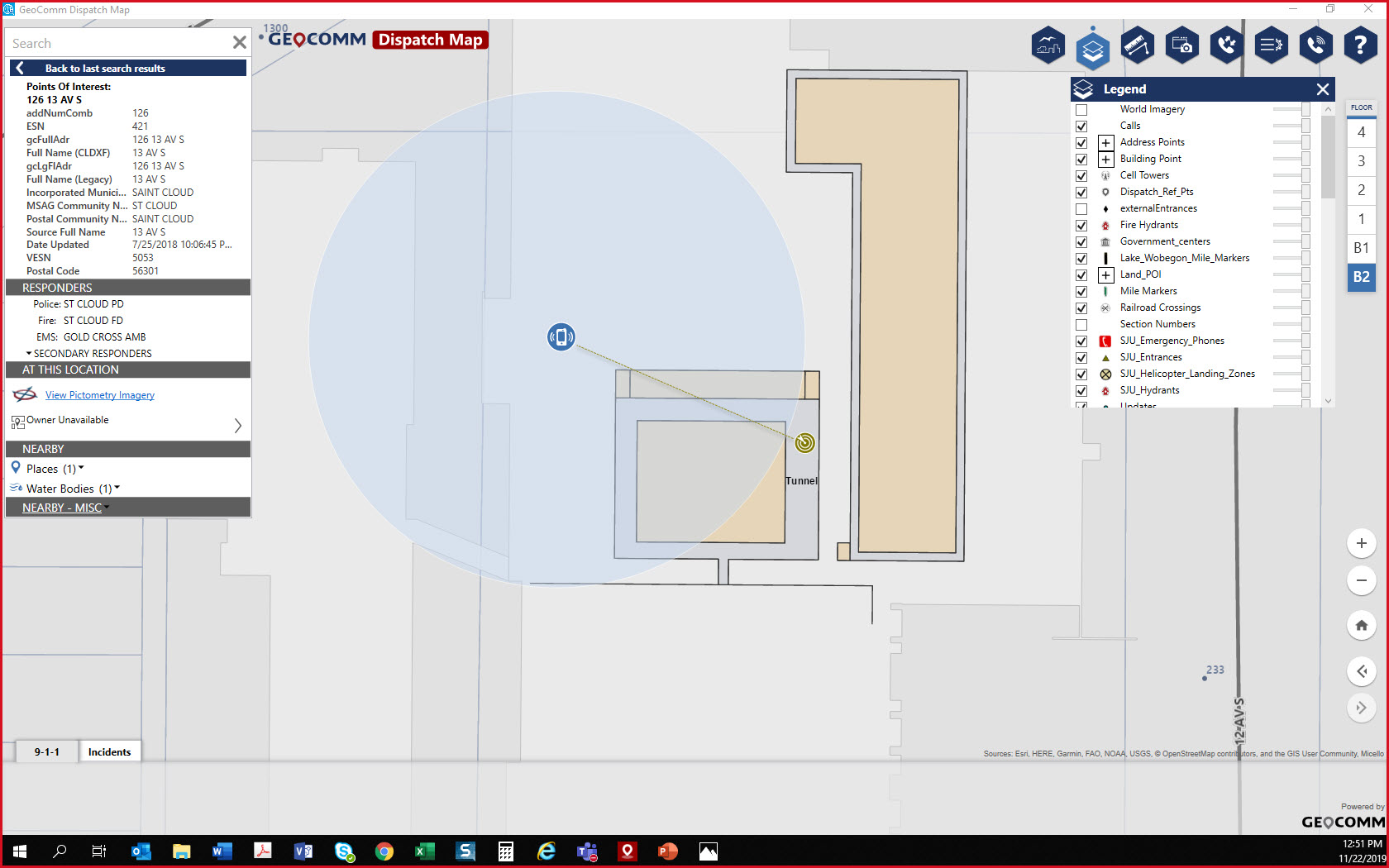
Building Without Indoor Context
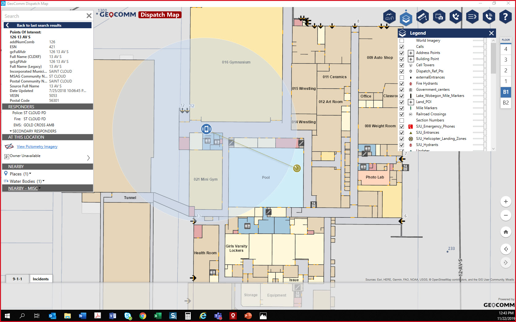
Indoor Map of Building