Indoor Mapping for Public Safety: GeoComm’s Public Safety Content Library (PSCL)
At GeoComm, innovation meets impact. A great example of this is our groundbreaking Public Safety Content Library (PSCL). Designed to revolutionize how 9-1-1 telecommunicators, dispatchers, and emergency responders can access and use critical indoor mapping during emergencies to reduce response times, PSCL is a secure, cloud-based indoor map data warehouse purpose-built for public safety.
What Is the PSCL?
PSCL stands for Public Safety Content Library, a centralized platform developed by GeoComm to host and deliver indoor maps and other vital public safety content. Whether it’s a 9-1-1 call originating from inside a school, a business, a government center, or a multitude of other building types, PSCL ensures that emergency personnel have indoor maps and information at their fingertips about the facilities and complex indoor environments they must enter and navigate during emergencies — helping them respond faster and smarter.
Why Indoor Mapping with the PSCL Matters
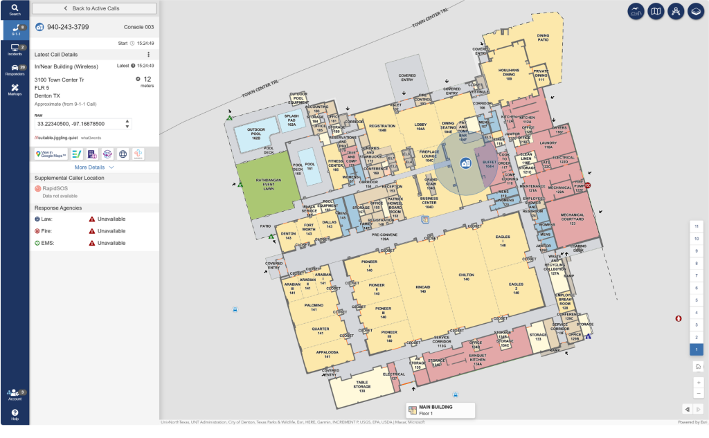
Imagine a 9-1-1 telecommunicator or dispatcher visualizing the exact layout of a building while guiding first responders to a caller’s location. Or emergency responders coordinating tactical responses using indoor maps on their mobile data computers. With PSCL, that’s not just possible—it’s already happening today.
PSCL integrates seamlessly with many existing 9-1-1, CAD, and mobile responder mapping applications providing indoor map content in formats tailored to each system, including Esri REST services, geoJSON, and vector tiles. GeoComm’s commitment to well-known and open web GIS services standards helps ensure that any modern software application can easily connect to, integrate, and display GeoComm PSCL indoor maps during emergencies.
Built for Public Safety
Unlike consumer oriented online mapping platforms, GeoComm’s PSCL is engineered to deliver public safety-grade streaming GIS data offering higher service level agreements (SLAs), robust security compliance, specific and tailored public safety software systems integrations, and access to secure, non-public, locally authoritative indoor map information. The PSCL is aligned with the NENA i3 9-1-1 GIS data model, ensuring E9-1-1 and NG9-1-1 interoperability and reliability when seconds count. From local to regional to state-wide implementations, see how GeoComm indoor maps streamed from the PSCL are being used to enhance safety and security inside the built environment.
Availability
9-1-1 PSAPs, Public Safety Agencies, and Software Vendors:
GeoComm’s PSCL web APIs are available to any authorized 9-1-1 or public safety vendor mapping application. If you are a 9-1-1 authority, or public safety software vendor and wish to learn more about accessing the PSCL, please contact GeoComm today.
GeoComm Indoor Map Data Build Customers:
All indoor maps built by GeoComm are eligible for inclusion in GeoComm’s PSCL. This is a fantastic way to improve safety and security of staff, students, guests, and customers inside your facilities in the event of critical emergencies – even if you primarily built your indoor maps to support non-emergency use cases such as facilities and asset management, space planning, or general purpose indoor wayfinding (of course you may still opt to not include your indoor maps in the GeoComm PSCL if not appropriate for your use case). For more information about sharing your indoor maps with the GeoComm PSCL please contact GeoComm today.
The Future of Public Safety Indoor Mapping
GeoComm’s PSCL is more than a product—it’s a commitment to safeguard communities through smarter, faster, and more connected access to maps and information about indoor locations and the built environment during emergencies. Learn more about how GeoComm is mapping the future of public safety at GeoComm.com


