School Emergency Preparedness: Hidden Gaps That Delay Effective Response
When we think of school emergency preparedness, the focus is often on the visible: drills, locked doors, communication protocols, and security personnel. But behind these measures are hidden gaps—vulnerabilities that only surface during a critical incident exposes them. These oversights can mean the difference between a coordinated response and a chaotic scramble.
Why School Emergency Preparedness Needs a Second Look
Emergencies unfold in seconds. Yet many school safety plans rely on outdated tools, vague directions, and disconnected systems. To truly protect students, staff, and first responders, emergency preparedness in schools must account for the unseen challenges.
Hidden Gap #1: First Responders Don’t Know the Layout
One of the most pressing challenges is the lack of building familiarity. First responders are often dispatched to schools they’ve never entered before. In these scenarios, they must rely on:
- Verbal directions from staff
- Static paper maps (if available)
- Guesswork in high-stress situations
This disconnect can lead to delays, confusion, and risk—especially in large or complex school buildings where every second counts.
Hidden Gap #2: No Shared Visual Between Stakeholders
In many school emergencies, 9-1-1 dispatch, school staff, and field responders operate on different levels of situational awareness. Without a shared visual reference, vital information about the incident’s location, building layout, or points of access can be misunderstood or entirely missed.
This lack of a common operating picture can:
- Hinder coordination
- Delay the response
- Compromise safety
Hidden Gap #3: Access Points Aren’t Clearly Defined
During a crisis, knowing which entrances and exits are locked, unlocked, or compromised can be critical—but this information often isn’t readily available to first responders.
Without real-time access point data, responders may:
- Attempt to enter through locked or obstructed doors
- Lose valuable time rerouting
- Compromise safety by entering less secure areas
Hidden Gap #4: Critical Locations Are Difficult to Pinpoint
In high-stress moments, a room number or wing label means little without context. Where is Room 212 in a sprawling building? What’s the fastest route to the gym from the east parking lot?
Without real-time visual navigation responders can:
- Misinterpret directions
- Lose time navigating hallways
- Miss opportunities to reach those in need quickly
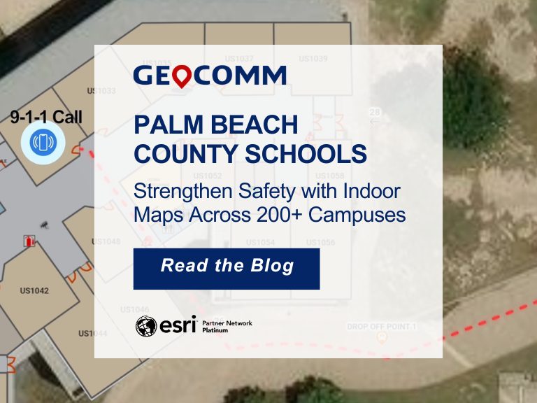
The Solution: Indoor Mapping for Smarter School Emergency Preparedness
Interactive indoor mapping technology bridges the gap between planning and real-time emergency response. These digital solutions are transforming how schools prepare for and respond to crises by offering:
- Real-time access to interactive school maps for 9-1-1, school staff, and field responders
- Turn-by-turn indoor navigation for faster response
- Dynamic updates that reflect building changes and crises developments
By integrating indoor maps into your school emergency preparedness strategy, you’re empowering every stakeholder with the tools they need to act quickly, confidently, and in sync.
It’s Time to Strengthen School Emergency Preparedness
True school emergency preparedness means going beyond the basics. It means tackling the quiet, often overlooked issues that can have life-or-death consequences. By recognizing these unspoken vulnerabilities and taking proactive steps to address them, schools can ensure a faster, safer, and more unified response when it matters most.
Ready to close the gap in your school’s emergency preparedness plan?
Download the guide, “10 Ways to Build a Safer, Smarter, School Safety Plan.”
Learn how our mapping technology helps responders navigate schools faster and safer.
How Minnesota First Responders Saved A Student’s Life using GeoComm School Safety
Speak to your Regional Manager for a free demo