Georgia

Enhancing Emergency Preparedness with School Mapping Data

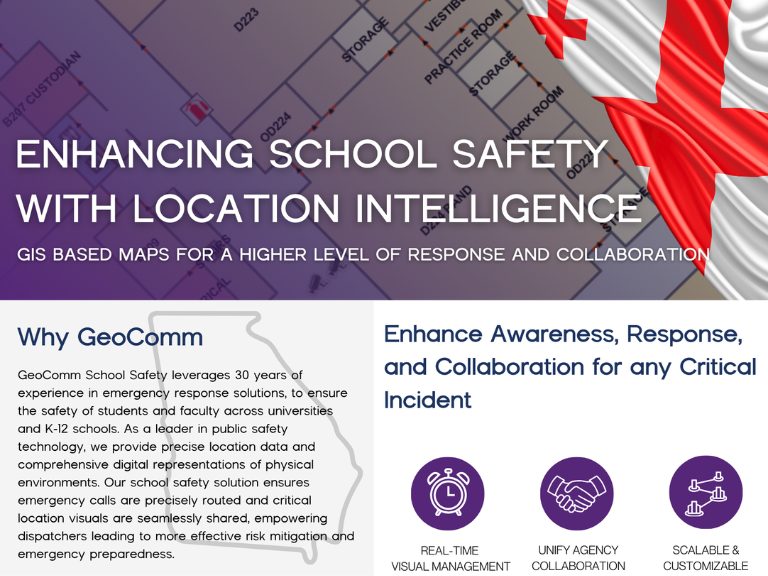
Learn how GeoComm helps Georgia schools comply with GA SB17 – Ricky and Alyssa’s Law by streamlining grant applications for school mapping data that improves safety and emergency response.

Navigate funding with Lara Crutcher your Regional Expert
By completing and submitting the form, I acknowledge GeoComm’s Privacy Policy.

Download the School Mapping Data Guide

Learn how Georgia schools can use school mapping data to comply with Ricky and Alyssa’s Law and improve emergency response
  • Detailed 2D-3D indoor visual depiction school campus and/or surrounding environment.
  • Integrates with live sensor feeds CAD, Incident management systems, location tracking, security cameras, alarms, and more.
  • Customizable points of interest room names and room numbers, fire extinguishers, cameras, water lines and more.
Downloadable handout for Georgia schools on Ricky and Alyssa’s Law and school mapping data requirements for emergency response.

GeoComm Meets All Requirements of Ricky and Alyssa’s Law for School Mapping Data

Helping first responders access precise data to improve response times. Our school mapping data solutions meet all program criteria:
  • Compatible with public safety software, no extra costs.
  • Supports printing, sharing, and mobile integration.
  • Verified annually via in-person inspection.
  • Labels interiors and exteriors with familiar identifiers.
  • Marks critical utilities and emergency aids.

Seamlessly Integrate with Mobile Panic Alert Systems

GA SB 17 requires all local school systems to implement a mobile panic alert system to provide real-time coordination between school officials and local first responder agencies to ensure efficient and effective emergency response.
wrapper-deco-left-raw
wrapper-deco-right-raw
school safety and critical incident mapping for schools
400 M+

Total Square Footage

Mapped Nationwide

school safety and critical incident mapping for schools
60

Implementation

Avg. Map Implementation Turnaround Time (30 Buildings or Fewer)

school safety and critical incident mapping for schools
2190 +

Hours Saved

Avg. Maintenance Time Saved by switching from Static PDFs to Responsive Digital Representations

  • “The addition of indoor maps integrated with our 9-1-1 software supports emergency personnel identification of specific room locations of 9-1-1 callers.” Greg Ballentine, Executive Director – Denco Area 9-1-1 District
Greg Ballentine Denco

Enhance School Safety with School Mapping Data Solutions

Comply with Ricky and Alyssa’s Law by leveraging school mapping data to enhance emergency response and protect your school community.
  • Reduce Manual Effort Save time and resources with dynamic maps
  • Collaborate at all levels Facilitate easier collaboration between all agencies
  • Personalize your maps Clearer, smarter visuals with custom school layouts

Ready to Apply for Your School Safety Funding?

Get expert help to align spending, tailor solutions, and ensure compliance for a safer school environment.

Share and Communicate with Agencies

Enhance communication through seamless integration with critical incident mapping across our partner network. From emergency response tools to top public safety solutions, we streamline data sharing for faster, more effective responses.

School Safety Resources

Bixby Public Schools Strengthens Emergency Preparedness With GeoComm’s School Safety Mapping Technology

St. Cloud, MN, February 16, 2026: Bixby Public Schools in Bixby, Oklahoma has partnered with GeoComm to implement districtwide school safety mapping across its 10 campuses, covering over 1.7 million square feet and supporting over 7,000 students. As one of the fastest -growing school districts in the state, Bixby Public Schools faced growing complexity in…

GeoComm Featured on WHO 13 News: Advancing School Safety in Iowa

Iowa schools are strengthening emergency preparedness with advanced 9-1-1 mapping and call-forwarding technology designed to give first responders faster, clearer situational awareness when every second matters. Through the statewide Critical Incident Mapping initiative, more than 1,400 schools across Iowa now have access to accurate, up-to-date indoor maps that support improved communication between school staff, 9-1-1…

2026 Texas DIR Contract and Pricing

GeoComm, a leading provider of geographic information and communication systems, has been awarded a Texas Department of Information Resources (DIR) contract DIR-CPO-4499 for GeoComm’s public safety software.