Next Generation 9-1-1 GIS Project for the State of North Carolina and NC 911 Board
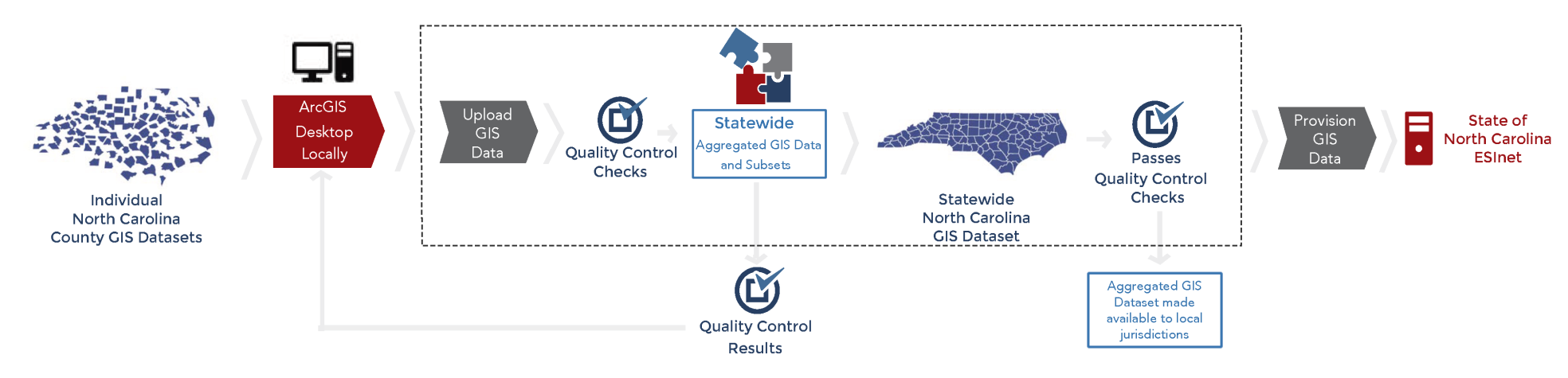
In the case of North Carolina and the NC 911 Board, the goal is to have a statewide 9-1-1 GIS synchronization and 9-1-1 database management services for routing 9-1-1 calls. The services required need to comply with NENA i3 NG9-1-1 GIS standards and support a fully functional NG9-1-1 geo-based call routing platform. This graphic shows how the State of North Carolina utilized and implemented GeoComm’s assess, improve, and maintain process to meet this objective.
North Carolina NG9-1-1 GIS Workflow
“The North Carolina 911 Board is very excited about the progress of our project and the active support and involvement of the PSAPs and GIS agencies in order to provide statewide 9-1-1 GIS quality,” stated Pokey Harris, North Carolina 911 Board Executive Director. “Further, working with GeoComm on our workflow processes that manage 9-1-1 data has been especially helpful in creating procedure for spatially managing the NG9-1-1 call routing.”
“We are excited to have had the opportunity to work with the State of North Carolina as they work to achieve statewide 9-1-1 GIS synchronization and 9-1-1 database management services for routing 9-1-1 calls which require compliance with NENA i3 NG9-1-1 GIS standards. By utilizing our proven NG9-1-1 GIS readiness process the individual jurisdictions are empowered to maintain their GIS data for use at the local level and also upload it to a central system for the state to complete a series of quality control checks focused on NG9-1-1 needs prior to merging into a statewide GIS data set for use in their NG9-1-1 system,” said Jessica Beierman, GISP – GeoComm GIS Project Manager.
This project highlights how each jurisdiction’s individual GIS data goes through the assess, improve, and maintain process to meet the ultimate goal of supporting a standardized fully functional NG9-1-1 geo-based call routing platform.
Gain new perspective through a GIS data assessment by taking a complete look at the current state of your GIS data and determining its NG9-1-1 readiness.


