Home > Press Releases > City of Austin, Texas Completes Project Aimed at Improving GIS Data Provided in Their CAD System
FacebookLinkedInXPinterestEmail
Dark Mode

City of Austin, Texas Completes Project Aimed at Improving GIS Data Provided in Their CAD System

“We sincerely appreciate all of GeoComm’s hard work for this public safety project.  The collaboration and professionalism everyone demonstrated throughout this project was wonderful.  We will certainly reach out to GeoComm if we need future GIS assistance,” said John Regalado – Public Safety IT Manager, City of Austin, Texas.

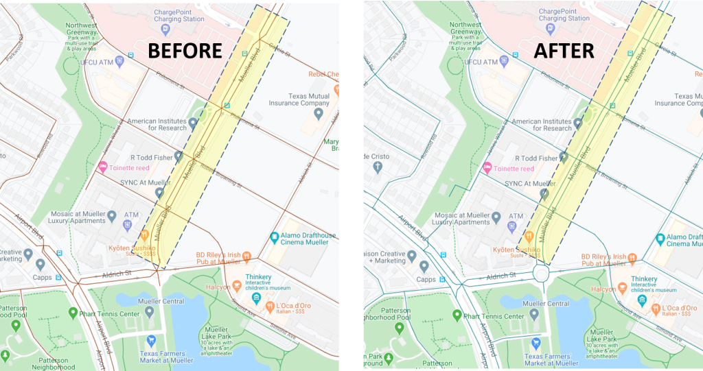
The City of Austin, Texas was recently experiencing some difficulties with spoken vehicle routing directions provided in their Computer Aided Dispatch (CAD) mobile units. Their main objective was to correct the roads segments on dual carriageway streets with a physical barrier for a median, which caused the segment to come together in a “pinched” fashion (see BEFORE pic). They requested GeoComm assist them with the project by completing spatial and attribute updates to their Road Centerline Layer to straighten the road segments into more “ladder-like” parallel lines (see AFTER pic). This resulted in improving the vehicle routing directions provided by CAD system to the mobile units.

April 21, 2020

GIS Resources

Bixby Public Schools Strengthens Emergency Preparedness With GeoComm’s School Safety Mapping Technology

St. Cloud, MN, February 16, 2026: Bixby Public Schools in Bixby, Oklahoma has partnered with GeoComm to implement districtwide school safety mapping across its 10 campuses, covering over 1.7 million square feet and supporting over 7,000 students. As one of the fastest -growing school districts in the state, Bixby Public Schools faced growing complexity in...

GeoComm Appoints TJ Kennedy as CEO to Lead Next Chapter in Public Safety Innovation

St. Cloud, MN – October 22, 2025 – GeoComm, today announced new executive leadership to accelerate its transformation as the nation’s most trusted provider of public safety GIS and indoor mapping.  TJ Kennedy has been named Chief Executive Officer bringing decades of expertise to advance GeoComm’s mission of delivering life-saving location intelligence for first responders,...

GIS-powered Critical Incident Mapping Helps Minnesota First Responders Reach a Medical Emergency Victim in Seconds

JACKSON COUNTY, Minn., March 24, 2025 /PRNewswire/ — A life-threatening medical emergency at a Jackson County high school on October 3rd, 2024 put First Responders to the test when a student suffered a medical complication in the cafeteria. Thanks to the swift response of the Jackson County Sheriff’s Department and GeoComm’s GIS-powered critical incident mapping technology, emergency personnel pinpointed the exact location within...