Home > Public Safety > 2019 Texas DIR Contract and Pricing
FacebookLinkedInXPinterestEmail
Dark Mode

2019 Texas DIR Contract and Pricing

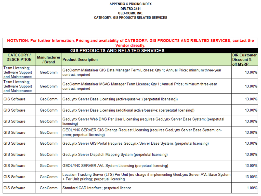
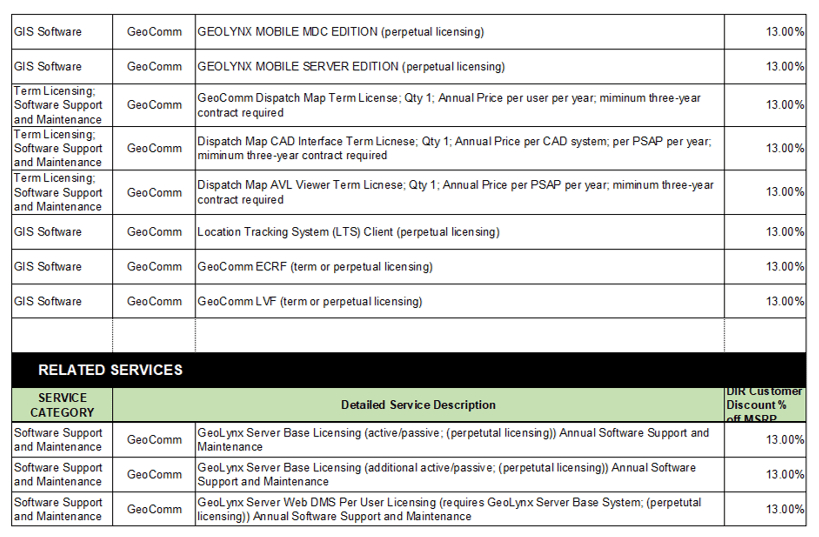
GeoComm, a leading provider of geographic information and communication systems, has been awarded a Texas Department of Information Resources (DIR) contract DIR-TSO-3441 for GeoComm’s public safety software.

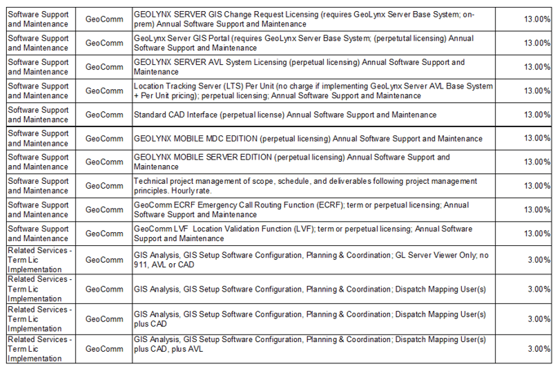
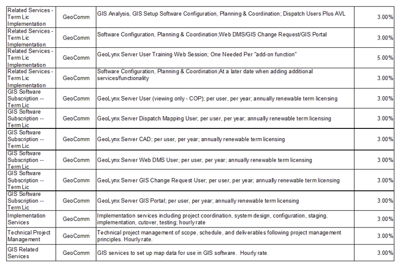
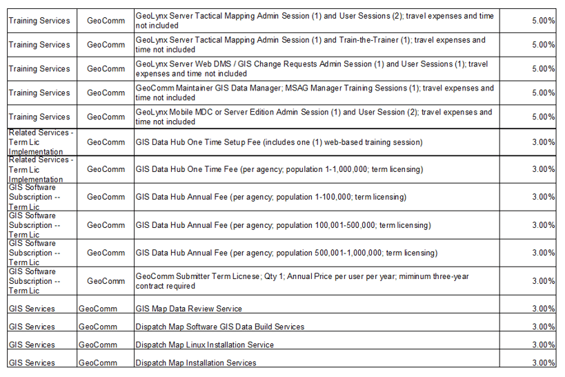
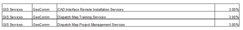
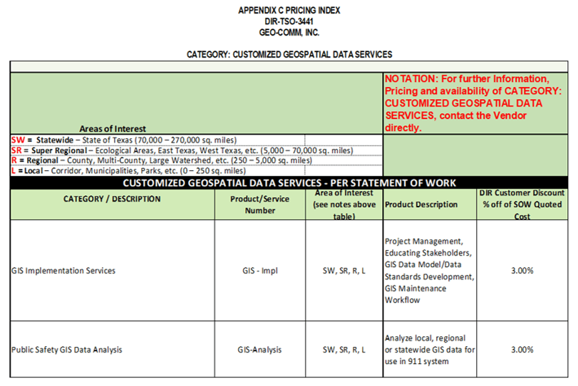
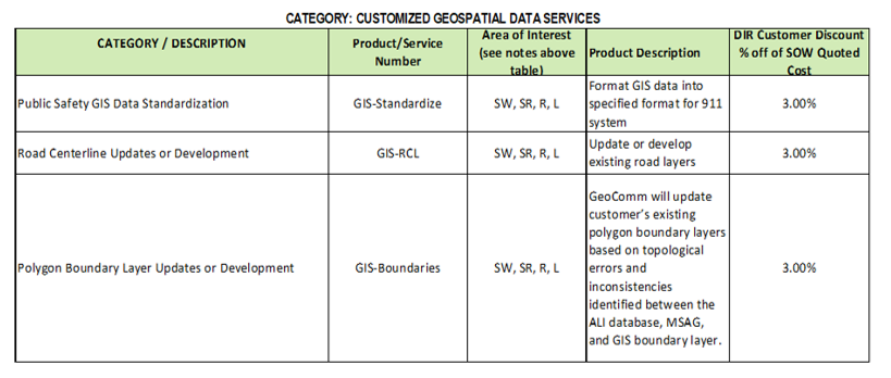
GeoComm’s software products provides an industry leading end-to-end 9-1-1 enterprise GIS software solution that meets all public safety and law enforcement GIS needs. Products and services covered in this contract include: NG9-1-1 software and servicesenterprise GIS data management software and services, and public safety mapping applications.

The Texas DIR contract simplifies the process for state and local government agencies in the State of Texas and elsewhere to purchase GeoComm’s public safety software offerings. This award is significant because it allows agencies to directly acquire products and services through the DIR contract, eliminating the need for a costly RFP process.

To obtain quotes and place order please contact Territory Sales Manager Ron Helterbrand at rhelterbrand@geocomm.com or (320) 281-2193 and reference contract number DIR-TSO-3441.  Ron will gather information in regards to what you are looking for and then present you with a proposal and/or quote for your review.

Warranty Policy: Products are offered under an annually renewable software support and maintenance agreement. Review GeoComm’s complete Terms and Conditions.

Learn more about the Texas DIR program.

June 28, 2018

GIS Resources

Avoiding 9-1-1 Call Failures: How PSAP Boundaries and NG9-1-1 Support Emergency Preparedness

As Next-Generation 9-1-1 (NG9-1-1) continues to evolve, accurate Public Safety Answering Point (PSAP) 911 service area boundaries are more crucial than ever for emergency services. This accuracy is also a foundational component of broader emergency preparedness strategies aimed at improving public safety outcomes. Why is this so important for emergency preparedness?   NG9-1-1 Emergency Call Routing Functions...

How Denco 9-1-1 Locates Callers Indoors Using GeoComm’s Indoor Mapping

Indoor Mapping for Emergency Response & Public Safety Overview: Denco 9-1-1 Enhances School Safety with Indoor Mapping Denco Area 9-1-1 District (Denco 9-1-1) partnered with GeoComm in late 2019 to tackle the critical challenge of locating 9-1-1 callers indoors. The Indoor Map Development Project aimed to enhance Emergency Communications Center (ECC) mapping capabilities by leveraging...

Southwest Minnesota: Digital Geographic Information System Mapping & 9-1-1 Emergency Response

Overview In 2023, the Southwest Minnesota Emergency Communications Board (SWECB) partnered with GeoComm to launch an indoor mapping pilot project. This digital geographic information system mapping initiative transformed critical infrastructure buildings into GIS-powered indoor maps, providing first responders with precise, real-time location intelligence and the school mapping data needed to ensure effective emergency response. The...